Monitoring shows improving salinities and mixed local trends across the Indian River Lagoon
May 09, 2026 | Sebastian , Indian River County, Florida
This article was created by AI summarizing key points discussed. AI makes mistakes, so for full details and context, please refer to the video of the full meeting. Please report any errors so we can fix them. Report an error »
Chair Hurd convened the management board meeting where St. Johns River Water Management District scientist Lorraine Simpson and South Florida Water Management District scientist Melanie Parker presented the latest monitoring through April 2026.
Simpson, presenting Northern and Central lagoon data, said a heavy April rain pulse raised district average rainfall to about 4 inches for the month and produced coincident drops in salinity at some nearshore sites, notably a Vero Beach station located just south of State Road 60 near the Main Relief Canal. Continuous stations show dissolved-oxygen concentrations remain above hypoxic thresholds for now; Simpson cautioned that rising temperatures could reduce oxygen in coming months. She reported a turbidity spike in Mosquito Lagoon and elevated fluorescent dissolved organic matter (FDOM) at one Vero site tied to freshwater inputs but said the patterns so far did not indicate sustained harm.
Parker, who presented Southern Lagoon and St. Lucie Estuary monitoring, said inflows to the estuary were low except for a mid-April spike and noted there have been no Lake Okeechobee releases to the St. Lucie Estuary since March 2025. At some monitoring locations salinities fell rapidly after the rain event but returned to an optimal range for adult oysters (10–25), improving conditions at the onset of spawning. Parker reported recent spat-settlement detections and quarterly oyster densities that suggest recruitment is on track for the season.
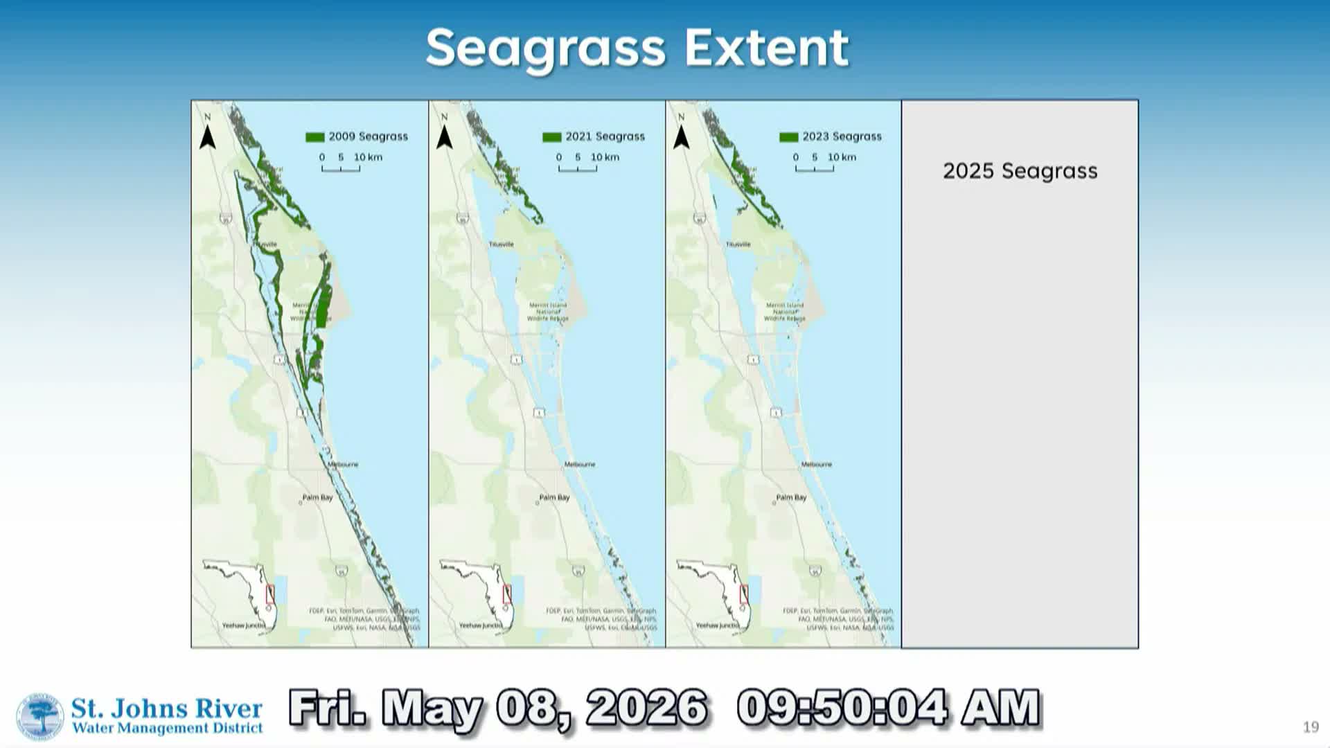
Both presenters addressed seagrass and macroalgae updates. Simpson said new 2025 mapping showed a large decline in Caulerpa coverage in a sampled region — from about 15,000 hectares in 2023 to roughly 4,000 hectares in 2025, a ~72% drop. Field crews found evidence that a tiny slug that feeds on Caulerpa prolifera had caused the decline; Simpson said the slug appeared to have been abundant before April mapping and that follow-up imagery showed regrowth in some areas. She advised partnering with specialists to track the slug and to verify whether the decline and recovery are temporary or signal a broader change.
Board members asked technical questions about station siting, sensor reliability and the lag time for biological responses; Simpson and Parker said some effects will only be clear after upcoming monitoring cycles. The management board did not take regulatory action at the meeting but directed staff to continue targeted monitoring and to share seagrass and mapping products with stakeholders.
The reports provided a mix of cautious optimism — improved oyster recruitment and recovering seagrass in places — and localized concerns such as spikes in turbidity and transient algal signals after heavy rains. Staff said they will track these metrics into summer surveys and regional transects.
Simpson, presenting Northern and Central lagoon data, said a heavy April rain pulse raised district average rainfall to about 4 inches for the month and produced coincident drops in salinity at some nearshore sites, notably a Vero Beach station located just south of State Road 60 near the Main Relief Canal. Continuous stations show dissolved-oxygen concentrations remain above hypoxic thresholds for now; Simpson cautioned that rising temperatures could reduce oxygen in coming months. She reported a turbidity spike in Mosquito Lagoon and elevated fluorescent dissolved organic matter (FDOM) at one Vero site tied to freshwater inputs but said the patterns so far did not indicate sustained harm.
Parker, who presented Southern Lagoon and St. Lucie Estuary monitoring, said inflows to the estuary were low except for a mid-April spike and noted there have been no Lake Okeechobee releases to the St. Lucie Estuary since March 2025. At some monitoring locations salinities fell rapidly after the rain event but returned to an optimal range for adult oysters (10–25), improving conditions at the onset of spawning. Parker reported recent spat-settlement detections and quarterly oyster densities that suggest recruitment is on track for the season.
Both presenters addressed seagrass and macroalgae updates. Simpson said new 2025 mapping showed a large decline in Caulerpa coverage in a sampled region — from about 15,000 hectares in 2023 to roughly 4,000 hectares in 2025, a ~72% drop. Field crews found evidence that a tiny slug that feeds on Caulerpa prolifera had caused the decline; Simpson said the slug appeared to have been abundant before April mapping and that follow-up imagery showed regrowth in some areas. She advised partnering with specialists to track the slug and to verify whether the decline and recovery are temporary or signal a broader change.
Board members asked technical questions about station siting, sensor reliability and the lag time for biological responses; Simpson and Parker said some effects will only be clear after upcoming monitoring cycles. The management board did not take regulatory action at the meeting but directed staff to continue targeted monitoring and to share seagrass and mapping products with stakeholders.
The reports provided a mix of cautious optimism — improved oyster recruitment and recovering seagrass in places — and localized concerns such as spikes in turbidity and transient algal signals after heavy rains. Staff said they will track these metrics into summer surveys and regional transects.
Don't Miss a Word: See the Full Meeting!
Go beyond summaries. Unlock every video, transcript, and key insight with a Founder Membership.
✓
Get instant access to full meeting videos
✓
Search and clip any phrase from complete transcripts
✓
Receive AI-powered summaries & custom alerts
✓
Enjoy lifetime, unrestricted access to government data
30-day money-back guarantee
