Planning commission backs amendments to Anchorage 2040 land‑use map to support institutional growth
March 02, 2026 | Anchorage Municipality, Alaska
This article was created by AI summarizing key points discussed. AI makes mistakes, so for full details and context, please refer to the video of the full meeting. Please report any errors so we can fix them. Report an error »
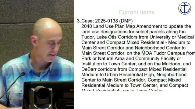
The Anchorage Planning and Zoning Commission on March 2 voted to recommend the Anchorage Assembly approve amendments to the Anchorage 2040 future land‑use map that would update land‑use designations at about 10 sites across East Anchorage and other areas to better support institutional growth and to remove conflicting split‑designations.
Daniel McKenna Foster of Long Range Planning said the project focuses on institutions such as the University of Alaska Anchorage, South Central Foundation and Saint Mary's Episcopal Church and on cleaning up split or inconsistent designations so property owners can pursue rezonings consistent with the 2040 plan. "The main focus of tonight is, changing the future land use map, in support of our institutions in Anchorage," Foster said.
The packet described sites where the 2040 designation and the underlying zoning do not align, producing practical barriers to institutional or redevelopment projects. Staff framed the amendments as policy‑level changes that would enable, but not automatically effect, future rezonings; Assembly review and formal rezone processes would still be required.
Maggie McKay, representing Saint Mary's Episcopal Church, said the parish supports the 2040 amendment and plans to pursue housing on church land. "We are envisioning 3 different housing units to bring a 120 different units onto our property," McKay said, describing the church's interest in supportive housing and a ‘proof of concept’ for other congregations with excess land.
Paul Hatcher, president of the Patterson Townhouse condominium association, expressed concern about a specific Tudor/Patterson parcel proposed for a designation change to a Main Street corridor. Hatcher said the site faces high‑speed traffic on Tudor, access limitations, and potential height differences that could affect adjacent multifamily and single‑family properties. "This site meets the definition of neighborhood center and should remain this," he told the commission.
Commissioners asked staff to clarify that the land‑use amendments did not automatically remove special limitations (SLs) or change zoning, and staff said the abbreviated rezone process remains an option for property owners but that rezonings would still require Assembly action. Commissioner Krishna moved to recommend Assembly approval of the plan amendments along Lake Otis Parkway, Tudor Road, Debar Road and Muldoon Road; Commissioner Ron seconded and the motion passed.
Staff also flagged several follow‑up items for commission and public consideration, including notification procedures, the interface with the abbreviated rezone process, infrastructure needs for some parcels, and the possibility of a legal briefing to help commissioners frame findings in future votes.
Don't Miss a Word: See the Full Meeting!
Go beyond summaries. Unlock every video, transcript, and key insight with a Founder Membership.
✓
Get instant access to full meeting videos
✓
Search and clip any phrase from complete transcripts
✓
Receive AI-powered summaries & custom alerts
✓
Enjoy lifetime, unrestricted access to government data
30-day money-back guarantee
