Presenter details CSDS rules and 10-year CSSRP watershed planning requirements
February 27, 2026 | State Water Resources Control Board, Boards and Commissions, Executive, California
This article was created by AI summarizing key points discussed. AI makes mistakes, so for full details and context, please refer to the video of the full meeting. Please report any errors so we can fix them. Report an error »
Presenter described Controllable Sediment Discharge Sources (CSDS) as "an order specific term describing a location or site that presents risk to water quality" and identified three qualifying conditions: the location "causes or threatens to cause impact to water quality," is "caused or affected by anthropogenic activity," and is "under permittee control and is treatable through management measures or BMPs."
The training directs Category B permittees to follow a three-step CSDS approach—assess, inventory, treat—and emphasizes that treatment is not required to be completed during the Category B activity; permittees may complete treatment in later projects or through a watershed treatment plan. Presenter noted that permittees must complete the initial CSDS assessment before submitting an NPO and add all identified CSDS to the CSDS map and inventory table, which are required submissions for the NPO and annual reporting. New CSDS observed during implementation must be added to the inventory and included in the annual report.
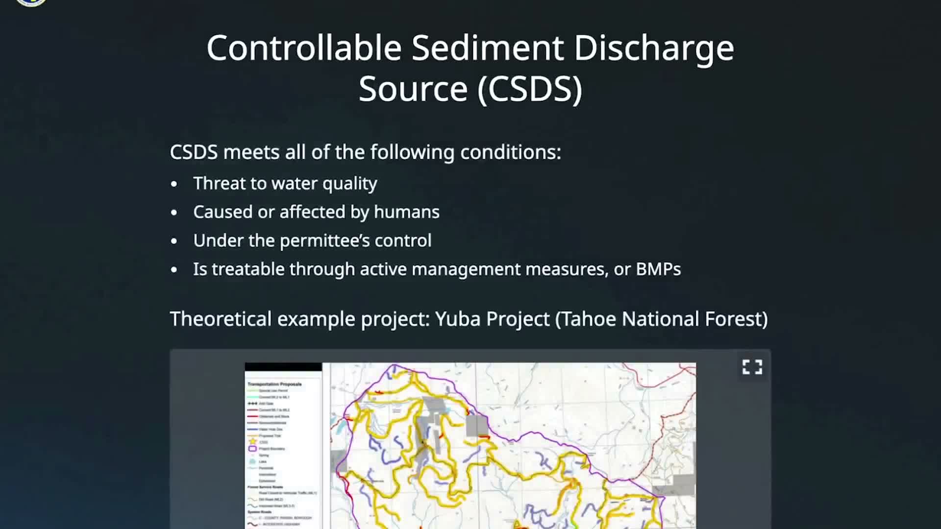
Presenter pointed to interactive map examples of CSDS: a culvert crossing at Howard Creek (class 3), a drafting site on a tributary to Salmon Creek (class 1), a bridge crossing at Haskell Creek (class 2), and culvert crossings at Chapman Creek and Sulphur Creek. The training says deferred CSDS treatments must be entered in a centralized inventory maintained by the permittee, monitored for the project life per MRP Attachment B, and made available to Central Valley Regional Water Quality Control Board staff upon request; permittees must justify any decision to defer treatment.
On watershed planning, Presenter explained CSSRP operates at the watershed level rather than at individual project footprints: permittees will cycle new watershed treatment plans every seven years and commit to completing treatment for the entire watershed within 10 years of those plans. As treatment progresses, permittees will report interim progress annually and submit a final completion report to the Central Valley Water Board. The training also instructs permittees to identify any overlap between new Category B project footprints and existing CSSRP assessments and to reuse CSSRP assessment findings where appropriate.
Why it matters: the CSDS and CSSRP provisions set out how permittees must identify, prioritize and track sediment-risk sites across projects and watersheds, and create an auditable inventory and reporting sequence that the Central Valley Regional Water Quality Control Board can request and review.
The unit directs participants to the CSDS assessment flowchart and the interactive SWRCB HUC Watershed Map for details on performing assessments and using the centralized inventory.
The training directs Category B permittees to follow a three-step CSDS approach—assess, inventory, treat—and emphasizes that treatment is not required to be completed during the Category B activity; permittees may complete treatment in later projects or through a watershed treatment plan. Presenter noted that permittees must complete the initial CSDS assessment before submitting an NPO and add all identified CSDS to the CSDS map and inventory table, which are required submissions for the NPO and annual reporting. New CSDS observed during implementation must be added to the inventory and included in the annual report.
Presenter pointed to interactive map examples of CSDS: a culvert crossing at Howard Creek (class 3), a drafting site on a tributary to Salmon Creek (class 1), a bridge crossing at Haskell Creek (class 2), and culvert crossings at Chapman Creek and Sulphur Creek. The training says deferred CSDS treatments must be entered in a centralized inventory maintained by the permittee, monitored for the project life per MRP Attachment B, and made available to Central Valley Regional Water Quality Control Board staff upon request; permittees must justify any decision to defer treatment.
On watershed planning, Presenter explained CSSRP operates at the watershed level rather than at individual project footprints: permittees will cycle new watershed treatment plans every seven years and commit to completing treatment for the entire watershed within 10 years of those plans. As treatment progresses, permittees will report interim progress annually and submit a final completion report to the Central Valley Water Board. The training also instructs permittees to identify any overlap between new Category B project footprints and existing CSSRP assessments and to reuse CSSRP assessment findings where appropriate.
Why it matters: the CSDS and CSSRP provisions set out how permittees must identify, prioritize and track sediment-risk sites across projects and watersheds, and create an auditable inventory and reporting sequence that the Central Valley Regional Water Quality Control Board can request and review.
The unit directs participants to the CSDS assessment flowchart and the interactive SWRCB HUC Watershed Map for details on performing assessments and using the centralized inventory.
Don't Miss a Word: See the Full Meeting!
Go beyond summaries. Unlock every video, transcript, and key insight with a Founder Membership.
✓
Get instant access to full meeting videos
✓
Search and clip any phrase from complete transcripts
✓
Receive AI-powered summaries & custom alerts
✓
Enjoy lifetime, unrestricted access to government data
30-day money-back guarantee
