Commission approves 21.64-acre rezone in Milton area amid access questions
August 20, 2025 | Morgan County Planning Commission, Morgan County Boards and Commissions, Morgan County, Utah
This article was created by AI summarizing key points discussed. AI makes mistakes, so for full details and context, please refer to the video of the full meeting. Please report any errors so we can fix them. Report an error »
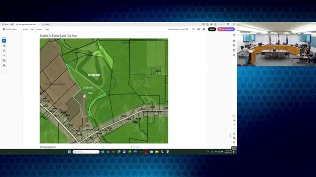
The Morgan County Commission on Aug. 19 approved Ordinance CO-25-16, rezoning 21.64 acres at 2272 West Chris Lane from Agriculture (A-20) to Ranch Residential (RR-5) and amending the county's future land use map to match the change.
The rezone passed 3-1 after a public hearing in which nearby residents, county planning staff and the property owners discussed site access and consistency with the Milton area plan. The commission's decision requires the applicant to meet subdivision standards for access if the property is later subdivided.
The applicant, Steve Winn, and co-owner Tucker Jensen told commissioners they bought the parcel recently and want to create two home sites while preserving open land along the river. Winn said the owners plan to extend a private lane through the adjoining Alquist Estates to provide the required frontage and would construct that lane to county standards.
Planning staff told the commission the planning commission had no public comments during its hearing July 17 and recommended findings supporting approval, including that the amendment aligns with adjacent RR-5 zoning and the county's future land use goals. Staff explained that access questions do not, by themselves, prevent a rezone because any future subdivision would be required to provide legal frontage and constructed access.
During the public comment period, resident Tina Kelly of Mountain Green cited the county general plan's Milton area plan, noting the plan describes the area as intended to develop at "no less than approximately 1 dwelling unit per 5 acres of land pursuant to county ordinances." Kelly urged commissioners to review that appendix before deciding.
Commission discussion ranged between adherence to area plans and recognition that rezonings and map amendments are discretionary decisions of the legislative body. Commissioner Newton said the parcel sits next to existing RR-5 zoning and canal-protected land and expressed support. Another commissioner voiced concern about cumulative densification in the area.
The motion to approve the ordinance and reflect the change on the future land use map carried 3-1. The commission's action updates zoning and the county's future land use map for the parcel; any future subdivision will be subject to frontage and access requirements and county subdivision standards.
Looking ahead, staff and the applicants will work through subdivision and access engineering if and when an application to divide the property is filed.
View the Full Meeting & All Its Details
This article offers just a summary. Unlock complete video, transcripts, and insights as a Founder Member.
✓
Watch full, unedited meeting videos
✓
Search every word spoken in unlimited transcripts
✓
AI summaries & real-time alerts (all government levels)
✓
Permanent access to expanding government content
30-day money-back guarantee
