Tribes, CalEPA and State Water Board staff held first California Native American Tribal GIS Summit, organizers say
September 05, 2025 | State Water Resources Control Board, Boards and Commissions, Executive, California
This article was created by AI summarizing key points discussed. AI makes mistakes, so for full details and context, please refer to the video of the full meeting. Please report any errors so we can fix them. Report an error »
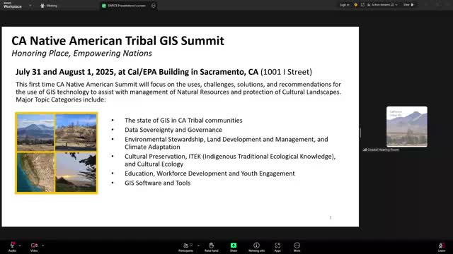
Dr. Donna Miranda Begay told the State Water Resources Control Board at the Sept. 3 public forum about the first California Native American Tribal GIS Summit, held in July at the CalEPA building and co‑hosted by the board and a tribal nonprofit. Begay said the free summit drew about 90 tribes (federally recognized and non‑federally recognized), roughly 280 in‑person participants and 230 virtual participants, and featured more than 20 presentations and six workshops.
Begay described summit goals as building tribal capacity to use geographic information systems (GIS) for protecting cultural landscapes, environmental justice, rematriation and land‑back efforts, and listed participating partners that included the Natural Resources Agency, CalEPA, the governor's office (land use and climate innovation), the Truth and Healing Council and universities. She credited board staff—naming Adriana Rentierra, Nathan Blacksmith, Molly Williams and Amy Croson—and Board Chair Joaquin Esquivel for helping host the event.
Why it matters: Tribal use of GIS can support tribal sovereignty, consultation, cultural‑landscape protection, wildfire and flood mapping, grant preparation and natural‑resource planning. Begay recommended that state public‑notice practices include GIS data when informing tribes of public land and water changes, and urged recognition of environmental and water components in land‑back and tribal mapping efforts.
Board response and next steps: Chair Esquivel thanked Begay for convening the summit and asked staff to publish the summit slides and recordings on the Water Board website. Begay said organizers are planning an annual statewide Tribal GIS Summit and invited board members and staff to consult materials on a shared Google Drive.
Ending: Begay said the summit facilitated co‑stewardship conversations and tribal mapping work; the board committed to making materials accessible online and continuing engagement with tribal partners.
Don't Miss a Word: See the Full Meeting!
Go beyond summaries. Unlock every video, transcript, and key insight with a Founder Membership.
✓
Get instant access to full meeting videos
✓
Search and clip any phrase from complete transcripts
✓
Receive AI-powered summaries & custom alerts
✓
Enjoy lifetime, unrestricted access to government data
30-day money-back guarantee
