Council approves small Lakeview South rezoning to consolidate split parcel
September 12, 2025 | Provo City Council, Provo, Utah County, Utah
This article was created by AI summarizing key points discussed. AI makes mistakes, so for full details and context, please refer to the video of the full meeting. Please report any errors so we can fix them. Report an error »
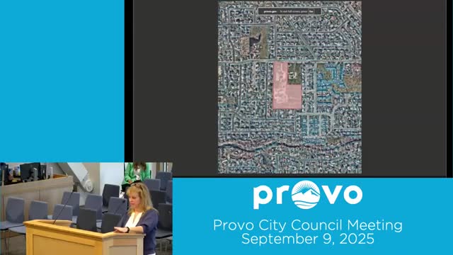
The Provo Municipal Council approved an ordinance to amend the zone map for property at 2525 West 620 North in the Lakeview South neighborhood, changing a 0.65-acre portion from R-1-8 single-family residential to A-1 agricultural.
Planner Nancy Robinson explained the request: the applicant will split the existing roughly 9.61-acre parcel into two pieces (about 3.66 acres and 5.95 acres) and wants the small portion joined to the adjacent agriculturally zoned land so the larger parcel is not split between zones.
Robinson said the ordinance contains the correct legal description of the parcel boundaries and that the zoning change is intended "to make things clear and correct and all lined up together."
The council recorded votes in favor from six members and one opposing vote; the motion passed 6-1. The roll call recorded a "no" vote from Councilor Hoban and "yes" votes from the other councilors who participated.
Why it matters: The rezoning consolidates parcel zoning so a single land holding will not be split between residential and agricultural zones, simplifying future land use and parcel splits.
Background and details: Robinson said the update adjusts staff report acreage to reflect a 7-foot line correction discovered after the planning commission hearing; the acreage figures in the ordinance were corrected to reflect the adjusted lot lines.
Public comment and applicant presence: The applicant was present but did not make additional public remarks and no members of the public offered comment before the council vote.
Next steps: The ordinance will be recorded in the city's zoning map and will take effect under the terms in the adopted ordinance.
Don't Miss a Word: See the Full Meeting!
Go beyond summaries. Unlock every video, transcript, and key insight with a Founder Membership.
✓
Get instant access to full meeting videos
✓
Search and clip any phrase from complete transcripts
✓
Receive AI-powered summaries & custom alerts
✓
Enjoy lifetime, unrestricted access to government data
30-day money-back guarantee
