Outside analyst presents five draft maps and simulation testing; staff to post maps for comment
September 22, 2025 | 2025 Utah Legislature, Utah Legislature, Utah Legislative Branch, Utah
This article was created by AI summarizing key points discussed. AI makes mistakes, so for full details and context, please refer to the video of the full meeting. Please report any errors so we can fix them. Report an error »
SALT LAKE CITY — The Legislative Redistricting Committee on Sept. 22 heard a technical presentation and demonstration of proposed maps from an outside analyst retained to test compliance with Proposition 4 and court guidance. Sean Trendy, an elections analyst and consultant, described how map simulations, compactness scores and measures of partisan symmetry were used to evaluate and compare options.
"All of these maps are zeroed out, so they're equally populated," Trendy told the committee after walking members through five draft maps labeled A through E. He said the maps prioritize Proposition 4 requirements in order: federal constitutional and Voting Rights Act compliance and equal population; minimizing municipal splits (with municipal boundaries prioritized over counties where conflicts exist); compactness and contiguity; preservation of communities of interest; and consideration of natural geographic boundaries. Trendy said he used several neutral ensembles of simulated maps — including a large Harvard-generated ensemble and custom simulations that respect local natural barriers and reservations — as a baseline for intent testing.
Trendy summarized the practical constraints the state faces: Salt Lake County’s 2020 population exceeds the ideal congressional district population, meaning the county must be split in any map that meets federal population-equality requirements. He also illustrated how different map choices reflect trade-offs among compactness, municipal splits and the location of population centers along the Wasatch Front.
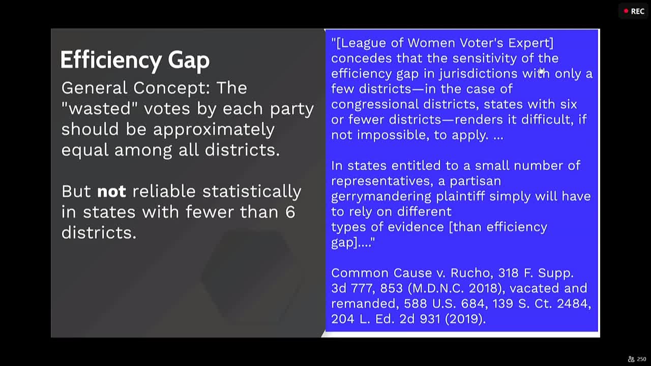
On partisan-symmetry testing, Trendy said the committee’s chosen statistical standard will be applied to actual past statewide vote data only after a proposed map is drawn (the committee will not be shown partisan metrics during map creation). "This is not something that happens in the creation of a map. It is after a map is created to go back and analyze that map," he said. Trendy also noted common technical limits: for example, the efficiency-gap metric is considered unreliable in states with fewer than six congressional districts, while partisan-bias (symmetry) measures directly assess whether maps give symmetrical seat outcomes under reciprocal vote shares.
Trendy presented five alternate configurations, each equal in population and designed to limit municipal splits and maintain reasonable compactness and transportation connections. He said the proposed maps fall within simulation ranges that staff used to check for partisan intent and that the maps were ready to be posted for public review. Committee chairs said staff will publish the proposed maps and open the court-ordered public comment period; the committee will reconvene to review input and decide next steps.
Why this matters: Technical analysis and neutral simulations are central to the committee's effort to produce a map that meets Proposition 4’s ordered standards while minimizing litigation risk. The methods chosen to test maps for partisan advantage will influence which maps the committee and potentially the court find acceptable.
What was decided: The committee received the technical briefing and did not adopt any map at the Sept. 22 meeting. Staff will post the proposed maps and run the required analyses; public comment will follow the court-directed schedule.
"All of these maps are zeroed out, so they're equally populated," Trendy told the committee after walking members through five draft maps labeled A through E. He said the maps prioritize Proposition 4 requirements in order: federal constitutional and Voting Rights Act compliance and equal population; minimizing municipal splits (with municipal boundaries prioritized over counties where conflicts exist); compactness and contiguity; preservation of communities of interest; and consideration of natural geographic boundaries. Trendy said he used several neutral ensembles of simulated maps — including a large Harvard-generated ensemble and custom simulations that respect local natural barriers and reservations — as a baseline for intent testing.
Trendy summarized the practical constraints the state faces: Salt Lake County’s 2020 population exceeds the ideal congressional district population, meaning the county must be split in any map that meets federal population-equality requirements. He also illustrated how different map choices reflect trade-offs among compactness, municipal splits and the location of population centers along the Wasatch Front.
On partisan-symmetry testing, Trendy said the committee’s chosen statistical standard will be applied to actual past statewide vote data only after a proposed map is drawn (the committee will not be shown partisan metrics during map creation). "This is not something that happens in the creation of a map. It is after a map is created to go back and analyze that map," he said. Trendy also noted common technical limits: for example, the efficiency-gap metric is considered unreliable in states with fewer than six congressional districts, while partisan-bias (symmetry) measures directly assess whether maps give symmetrical seat outcomes under reciprocal vote shares.
Trendy presented five alternate configurations, each equal in population and designed to limit municipal splits and maintain reasonable compactness and transportation connections. He said the proposed maps fall within simulation ranges that staff used to check for partisan intent and that the maps were ready to be posted for public review. Committee chairs said staff will publish the proposed maps and open the court-ordered public comment period; the committee will reconvene to review input and decide next steps.
Why this matters: Technical analysis and neutral simulations are central to the committee's effort to produce a map that meets Proposition 4’s ordered standards while minimizing litigation risk. The methods chosen to test maps for partisan advantage will influence which maps the committee and potentially the court find acceptable.
What was decided: The committee received the technical briefing and did not adopt any map at the Sept. 22 meeting. Staff will post the proposed maps and run the required analyses; public comment will follow the court-directed schedule.
Don't Miss a Word: See the Full Meeting!
Go beyond summaries. Unlock every video, transcript, and key insight with a Founder Membership.
✓
Get instant access to full meeting videos
✓
Search and clip any phrase from complete transcripts
✓
Receive AI-powered summaries & custom alerts
✓
Enjoy lifetime, unrestricted access to government data
30-day money-back guarantee
