Residents Alarmed as Floodplain Maps Reveal Increased Risks
October 25, 2024 | Franklin City, Williamson County, Tennessee
This article was created by AI summarizing key points discussed. AI makes mistakes, so for full details and context, please refer to the video of the full meeting. Please report any errors so we can fix them. Report an error »
In a recent government meeting, officials discussed significant changes to floodway and floodplain maps affecting the Brown Land Farms area and surrounding neighborhoods in Franklin. The meeting highlighted the implications of these changes for local development and property insurance requirements.
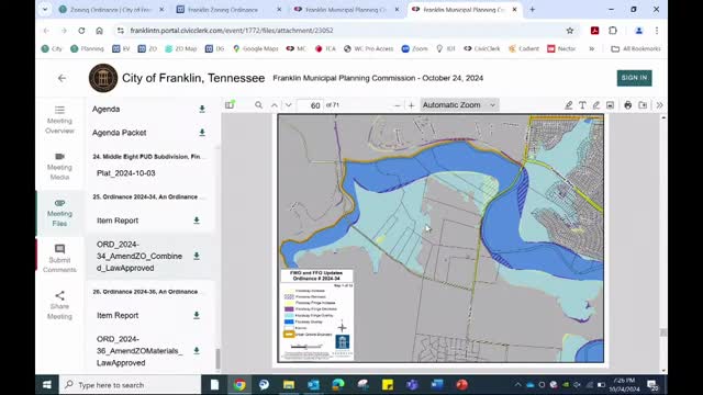
The floodway, identified as the most hazardous area during flood events, has seen both increases and decreases in designated zones. Areas marked in yellow indicate an increase in floodway, while purple signifies a decrease. The floodway fringe, where water backs up during floods, also experienced slight adjustments. Officials noted that these changes would not drastically impact development potential in the Brown Land Farms area, although any construction would require extensive hydrologic studies and potential elevation of properties to mitigate flood risks.
Residents expressed concerns about how these changes might affect their properties, particularly regarding flood insurance requirements. One resident pointed out that the new maps could force homeowners back into floodplain designations, potentially impacting property values and insurance costs. Officials clarified that any construction in newly designated flood areas would necessitate removing land from the floodplain, which involves rigorous studies and FEMA approval.
The discussion also touched on the broader implications of increased development in the region, with residents questioning whether new constructions could exacerbate flooding issues. Officials reassured attendees that city ordinances are in place to prevent new developments from negatively impacting existing properties. However, they acknowledged that changes in the larger drainage basin, which are outside the city's control, could still affect floodplain designations.
Overall, the meeting underscored the complexities of flood management in the face of urban development and the importance of community awareness regarding flood risks and insurance implications.
Don't Miss a Word: See the Full Meeting!
Go beyond summaries. Unlock every video, transcript, and key insight with a Founder Membership.
✓
Get instant access to full meeting videos
✓
Search and clip any phrase from complete transcripts
✓
Receive AI-powered summaries & custom alerts
✓
Enjoy lifetime, unrestricted access to government data
30-day money-back guarantee
